


THE LATEST
-
Harrison Central boys soccer sees tough stretch
-
Lady Huskies snap skid, face tough week on the field
-
Road work progresses on U.S. 22 and U.S. 250 projects in Harrison County
-
Scio council approves alley paving by 3-2 vote despite concerns over priorities
-
Lakeland Academy teacher Desiree Bender finds purpose in guiding and inspiring students
-
Mental Health and Recovery Board issues 2025 annual report for tri-county region
-
Humane Society of Harrison County elects new leaders, plans October fundraiser
-
Enchanted Harvest Ball for adults 50 and older set for Oct. 15 at Wallace Lodge
-
Village council debates police cruiser purchases amid budget concerns
-
Harrison Central volleyball celebrates seniors Jaylin Ward and Hannah Grady
LOCAL


SPORTS


Powered by
Find us on Facebook
Harrison News-Herald
COMMUNITY


COLUMNISTS
-

Column: Living on full, not empty
-
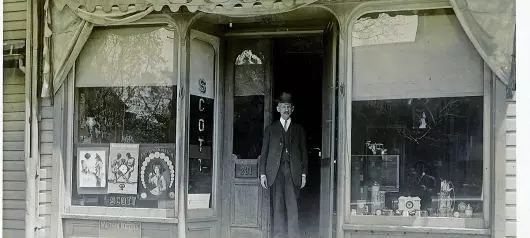
Column: Scott Jewelry Store, 1916
-
Column: A lesson in great faith from the Shunemmite woman
-
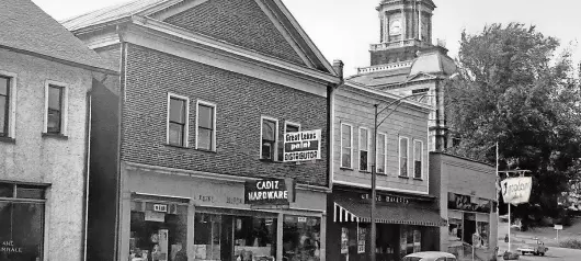
Column: Historic look at South Main Street in Cadiz
-

Column: Don’t be surprised when the world turns against faith
-

Column: Pep Fuels on Lincoln Avenue in 1990
-

God delights in you
-

Hating evil, loving righteousness: part two
-

Finnical's Pharmacy
-
Hating evil, loving righteousness: part one


